Nombre total de pages vues

18/05/2020

Science & Technology - Astronomy picture of the day : Journey into the Cosmic Reef

Journey into the Cosmic Reef
Video Credit: NASA's GSFC, SVS; Lead Producer & Music: Joseph DePasquale (STScI)
Explanation: What would you see if you could fly into the Cosmic Reef? The nebular cloud NGC 2014 appear to some like an ocean reef that resides in the sky, specifically in the LMC, the largest satellite galaxy of our Milky Way Galaxy. A detailed image of this distant nebula was taken by the Hubble Space Telescope to help commemorate 30 years of investigating the cosmos. Data and images of this cosmic reef have been combined into the three-dimensional model flown through in the featured video. The computer animated sequence first takes you past a star cluster highlighted by bright blue stars, below pillars of gas and dust slowly being destroyed by the energetic light and winds emitted by these massive stars. Filaments of gas and dust are everywhere, glowing in the red light of hydrogen and nitrogen. The animation next takes you to the blue-colored nebula NGC 2020, glowing in light emitted by oxygen and surrounding a Wolf-Rayet star about 200,000 times brighter than our Sun -- a nebula thought to be the ejected outer atmosphere of this stellar monster. As the animation concludes, the virtual camera pivots to show that NGC 2020 has a familiar hourglass shape when viewed from the side.
17/05/2020

Science & Technology - Astronomy picture of the day : A Waterspout in Florida

2020 May 17
See Explanation.  Clicking on the picture will download
the highest resolution version available.

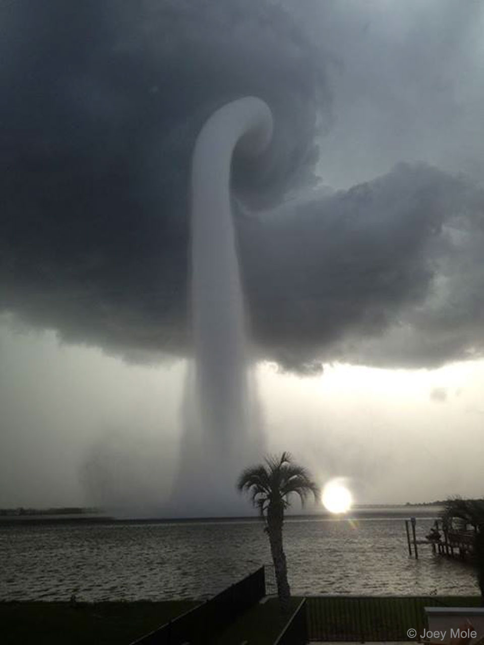
A Waterspout in Florida
Image Credit & Copyright: Joey Mole

Explanation: What's happening over the water? Pictured here is one of the better images yet recorded of a waterspout, a type of tornado that occurs over water. Waterspouts are spinning columns of rising moist air that typically form over warm water. Waterspouts can be as dangerous as tornadoes and can feature wind speeds over 200 kilometers per hour. Some waterspouts form away from thunderstorms and even during relatively fair weather. Waterspouts may be relatively transparent and initially visible only by an unusual pattern they create on the water. The featured image was taken in 2013 July near Tampa Bay, Florida. The Atlantic Ocean off the coast of Florida is arguably the most active area in the world for waterspouts, with hundreds forming each year.

04/05/2020

Science & Technologie - Santé - Le virus décodé ?

Coronavirus : des chercheurs identifient un anticorps prometteurUn anticorps monoclonal capable en laboratoire de neutraliser le virus SARS-CoV-2, responsable du Covid-19, a été identifié par une équipe de chercheurs néerlandais.

Cet anticorps neutralisant contre le coronavirus responsable du Covid et aussi contre celui responsable du Sras de 2003, pourrait constituer une piste pour la "prévention et le traitement" de ces maladies, selon l'article des chercheurs publié lundi par la revue scientifique Nature.

L'équipe associée à l'Université d'Utrecht et au Centre médical Erasmus de Rotterdam sous la direction de Berend-Jan Bosch et de Frank Grosveld, a créé 51 lignées cellulaires produisant des anticorps visant une protéine remarquable à la surface des deux coronavirus. Cette même protéine est impliquée dans l'arrimage du virus SARS-CoV-2 au récepteur ACE2 à la surface des cellules humaines et joue un rôle clé dans le processus infectieux du Covid-19. Un test a ensuite été mis au point pour déterminer si les anticorps étaient capables de neutraliser les deux coronavirus. Un de ces anticorps a montré une "activité neutralisante" tant sur le virus du Covid-19 que sur celui du Sras.

D H - Belgique 

02/05/2020

Science & Technology - Astronomy picture of the day : Cassini Approaches Saturn

2020 may 02
Cassini Approaches Saturn
Video Credit & Copyright: Cassini Imaging Team, ISS, JPL, ESA, NASA, S. Van Vuuren et al.;
Music: Adagio for Strings (NY Philharmonic)
Explanation: What would it look like to approach Saturn in a spaceship? One doesn't have to just imagine -- the Cassini spacecraft did just this in 2004, recording thousands of images along the way, and hundreds of thousands more since entering orbit. Some of Cassini's early images have been digitally tweaked, cropped, and compiled into the featured inspiring video which is part of a larger developing IMAX movie project named In Saturn's Rings. In the concluding sequence, Saturn looms increasingly large on approach as cloudy Titan swoops below. With Saturn whirling around in the background, Cassini is next depicted flying over Mimas, with large Herschel Crater clearly visible. Saturn's majestic rings then take over the show as Cassini crosses Saturn's thin ring plane. Dark shadows of the ring appear on Saturn itself. Finally, the enigmatic ice-geyser moon Enceladus appears in the distance and then is approached just as the video clip ends. After more than a decade of exploration and discovery, the Cassini spacecraft ran low on fuel in 2017 was directed to enter Saturn's atmosphere, where it surely melted.

01/05/2020

Science & Technologie - La Terre vue du ciel : L’île de Kyūshū au Japon

L’île de Kyūshū au Japon
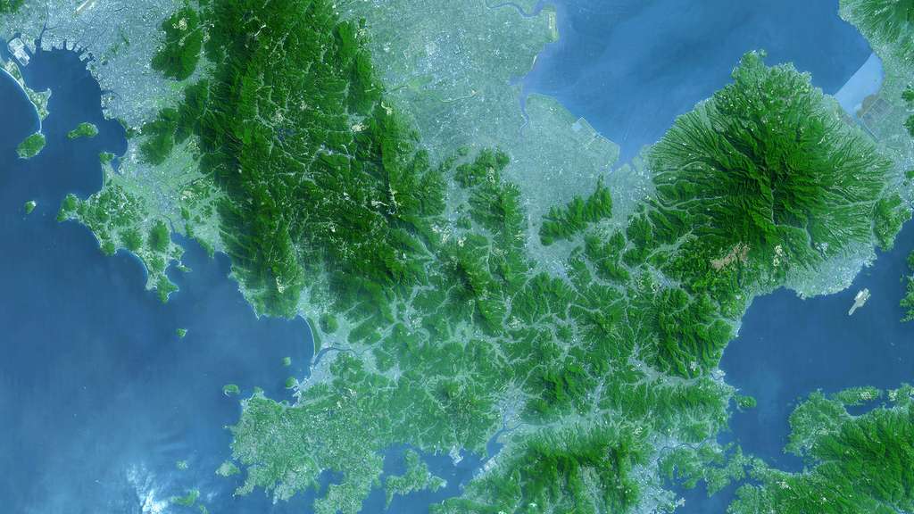
L'île de Kyūshū est la parfaite illustration de la complexité de l'œkoumène du Japon qui se trouve à l'intersection de quatre plaques tectoniques : le Pacifique, la mer des Philippines, l'Amérique du Nord, et l'Eurasie. Kyūshū se situe sur une zone de subduction où une plaque tectonique plonge sous une autre, donnant naissance à une topographie mêlant montagnes, plaines, volcans actifs (mont Unzen) et éteints (mont Tara).

Sur cette image satellite dont les couleurs ont été simulées, l'eau est bleue, la végétation verte et les zones urbaines sont en blanc et dégradé de bleu-gris. On peut ainsi se rendre compte de l'intrication complexe entre les zones habitées et montagneuses.

© Nasa

Science & Technology - Astronomy picture of the day : Around the World at Night

Around the World at Night
Video Credit & Copyright: Jeff Dai (TWAN, IDA), Music: Peter Jeremias
Explanation: Watch this video. In only a minute or so you can explore the night skies around planet Earth through a compilation of stunning timelapse sequences. The presentation will take you to sites in the United States, Germany, Russia, Iran, Nepal, Thailand, Laos and China. You might even catch the view from a small island in the southeastern Pacific Ocean. But remember that while you're home tonight, the night sky will come to you. Look up and celebrate the night during this International Dark Sky Week.


23/04/2020

Science & Technology - Astronomy picture of the day : Lyrid Meteor Streak

2020 April 23
Lyrid Meteor Streak
Image Credit & Copyright: Zolt Levay
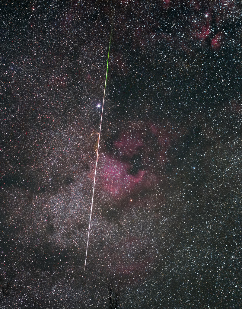
Explanation: Earth's annual Lyrid Meteor Shower peaked before dawn yesterday, as our fair planet plowed through debris from the tail of long-period comet Thatcher. In crisp, clear and moonless predawn skies over Brown County, Indiana this streak of vaporizing comet dust briefly shared a telephoto field of view with stars and nebulae along the Milky Way. Alpha star of the constellation Cygnus, Deneb lies near the bright meteor's path along with the region's dark interstellar clouds of dust and the recognizable glow of the North America nebula (NGC 7000). The meteor's streak points back to the shower's radiant, its apparent point of origin on the sky. That would be in the constellation

22/04/2020

Science & Technology - Astronomy picture of the day : Planet Earth at Twilight

2020 April 22
See Explanation.  Clicking on the picture will download
the highest resolution version available.

Planet Earth at Twilight
Image Credit: ISS Expedition 2 Crew, Gateway to Astronaut Photography of Earth, NASA

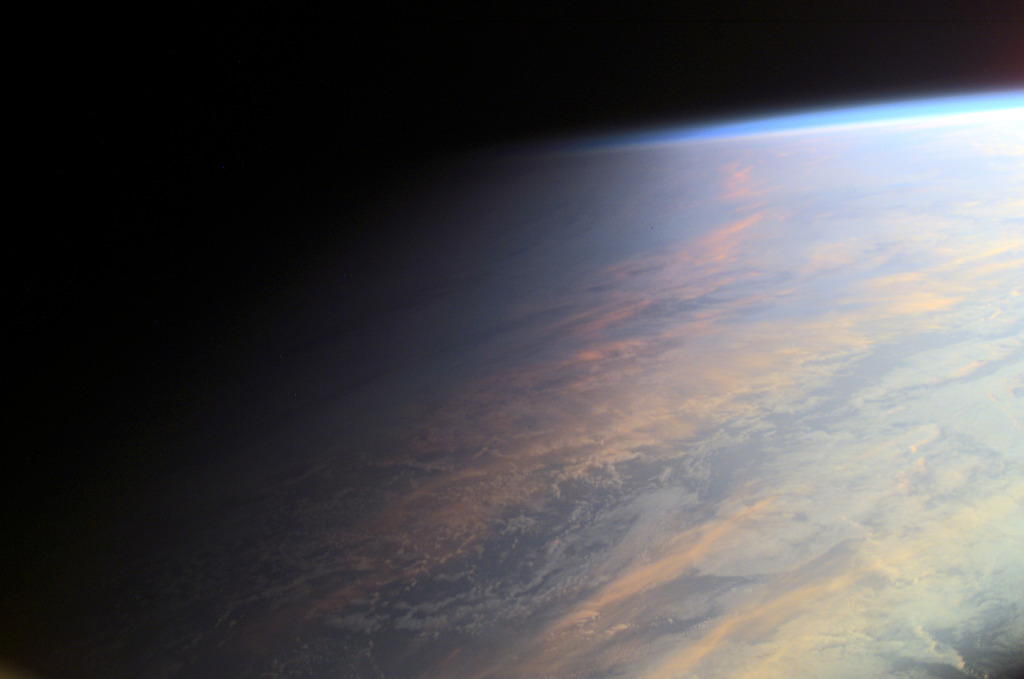
Explanation: No sudden, sharp boundary marks the passage of day into night in this gorgeous view of ocean and clouds over our fair planet Earth. Instead, the shadow line or terminator is diffuse and shows the gradual transition to darkness we experience as twilight. With the Sun illuminating the scene from the right, the cloud tops reflect gently reddened sunlight filtered through the dusty troposphere, the lowest layer of the planet's nurturing atmosphere. A clear high altitude layer, visible along the dayside's upper edge, scatters blue sunlight and fades into the blackness of space. This picture was taken in June of 2001 from the International Space Station orbiting at an altitude of 211 nautical miles. Of course from home, you can check out the Earth Now.

20/04/2020

Science & Tecnology - Astronomy picture of the day : IC 2944: The Running Chicken Nebula

See Explanation.  Clicking on the picture will download
the highest resolution version available.


IC 2944: The Running Chicken Nebula
Image Credit & Copyright: Juan Filas

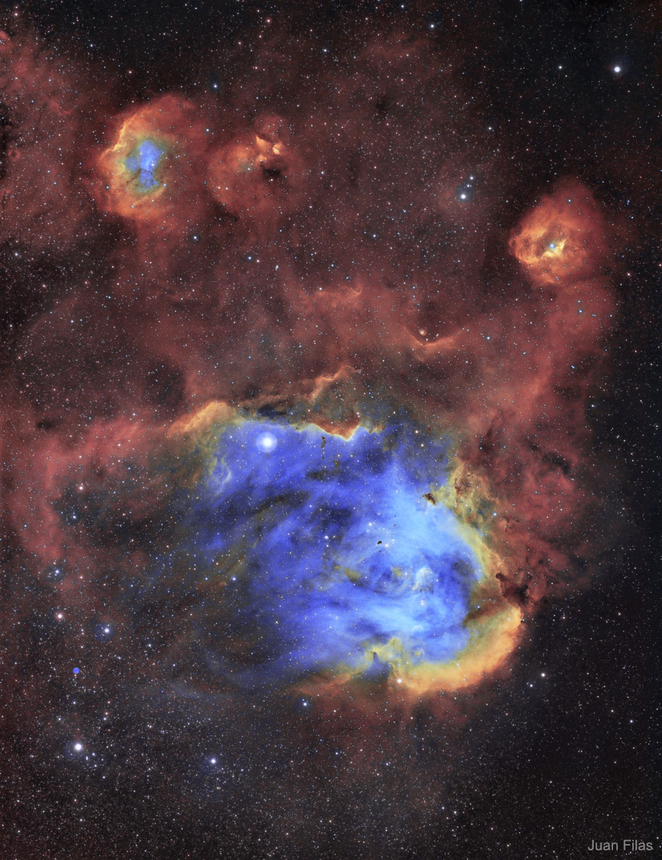
Explanation: To some, it looks like a giant chicken running across the sky. To others, it looks like a gaseous nebula where star formation takes place. Cataloged as IC 2944, the Running Chicken Nebula spans about 100 light years and lies about 6,000 light years away toward the constellation of the Centaur (Centaurus). The featured image, shown in scientifically assigned colors, was captured recently in a 12-hour exposure. The star cluster Collinder 249 is visible embedded in the nebula's glowing gas. Although difficult to discern here, several dark molecular clouds with distinct shapes can be found inside the nebula.

19/04/2020

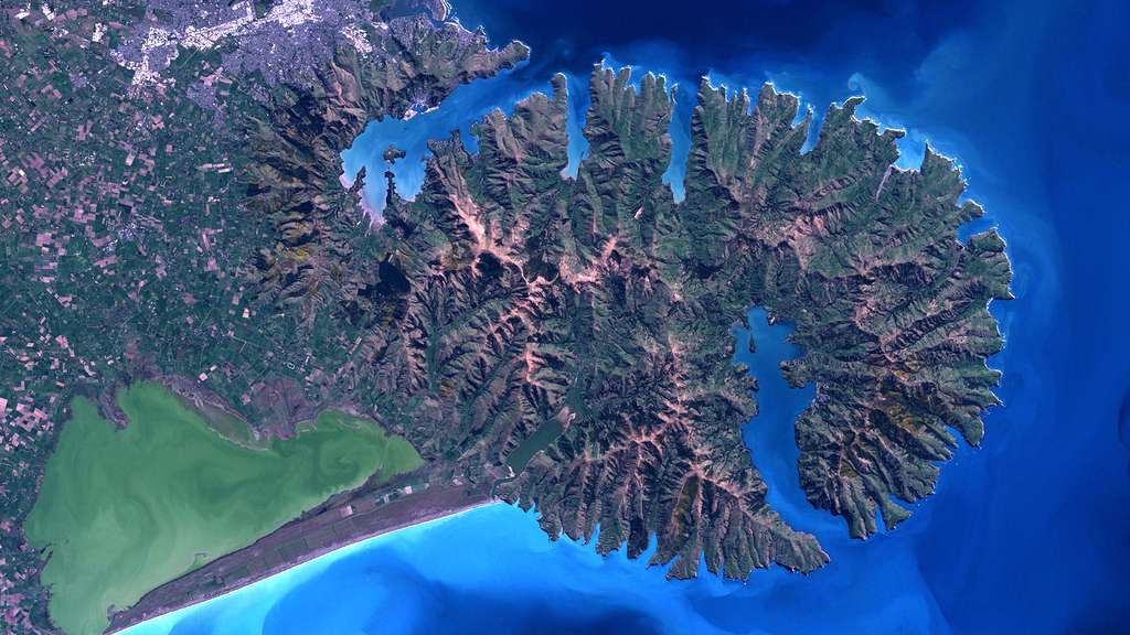
Science & Technologie - La Terre vue de l'Espace : La ville de Christchurch en Nouvelle-Zélande

La ville de Christchurch, en Nouvelle-Zélande
Deuxième plus grande ville de Nouvelle-Zélande, Christchurch est située sur la côte est de l'île du Sud, près de la pointe sud de la baie de Pegasus. Elle est bordée au nord par la rivière Waimakariri et au sud par la péninsule de Banks. L'île du Sud est parcourue de rivières en tresses qui charrient les roches arrachées aux Alpes du Sud et viennent nourrir les plaines alluviales de Canterbury. Ce type de rivières, faites de nombreuses connexions entre ses bras, est très rare. Hormis la Nouvelle-Zélande, on en trouve en Alaska, au Canada, et dans l'Himalaya. La péninsule de Banks se compose de deux volcans éteints qui se chevauchent, nommés Lyttelton et Akaroa. Inactifs depuis six millions d'années, ils se sont peu à peu érodés, passant d'une altitude de 1.500 à 500 mètres. On distingue deux grandes brèches dans les parois du cratère qui sont devenues des ports naturels, celui de Lyttelton au nord et celui d'Akaroa au sud. 
© Nasa

AERONAUTIQUE - La grande épopée des ballons dirigeables - 1904 : Baldwin's Airship

Né en 1854, Thomas Scott Baldwin a commencé sa carrière comme serre-freins dans une compagnie de chemin de fer de l'Illinois (États-Uni...